 |
|
 |
|||||||
Raw data of the weather radar for the broader area of Athens are available since 2005.
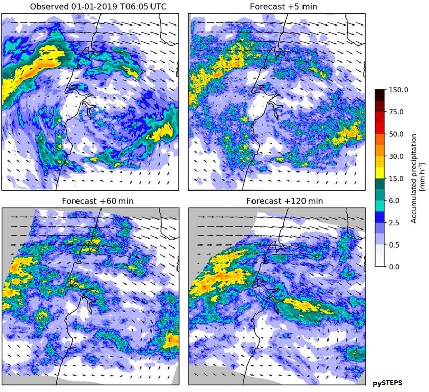
The RadCast (Radar nowCast) algorithm was developed by the Institute of Environmental Research & Sustainable Development (IERSD) for the very short-term forecast (nowcast) of rainfall up to 1 hour ahead. The algorithm estimates the track and the change of intensity of rainfall field using only weather radar data from the immediately preceding time period (usually one hour).
Status: operational
Read more/less
Ιn this web page forecast rainfall maps are shown in nearly real-time for the broader area of Attica every 5-15 minutes based on RadCast algorithm and data from the weather radar of IERSD in Palaia Penteli, Athens, whenever it is available (see Radar page). The velocity shown corresponds to the transport velocity of rainfall field.
The nowcast with RadCast is more accurate for time periods ahead typically of 1 hour compared to the nowcast after assimilation of radar data in a weather forecasting model (see Nowcast page).
This forecast is a research product and not an official operational product. IERSD/NOA and its personnel assume no responsibility for consequences that may arise from the use of this forecast.
|
|
|||
|
Institute of Environmental Research & Sustainable Development National Observatory of Athens I. Metaxa & V. Pavlou, 15236 Palaia Penteli Athens, Greece |
Page last modified: August 4,2024
|
||